
A new assessment study identifies areas in Mexico City’s metro system affected by land subsidence, providing a roadmap for mitigating damage, prioritizing repairs, and informing future designs for the metro’s infrastructure.
Using satellite radar data and structural engineering analyses, the research team identified zones where the rate of subsidence changes rapidly.
Subsidence is a naturally occurring phenomenon, but often amplified by human activity such as groundwater extraction. Mexico City is built within a mountain basin over a variable thickness layer of soft lake sediments. Excessive groundwater extraction in the city has led to rapid subsidence with rates reaching nearly 20 inches per year. Sharp changes in subsidence rates from low to fast subsiding areas cause progressive damage to the city’s core infrastructure, including the Mexico City Metro, which is the second largest metro system in North America after the New York City Subway.
“By comparing two or more radar observations from roughly the same location in space, we can detect small changes of the Earth’s surface with centimeter-level accuracy,” said Shimon Wdowinski, FIU geophysics professor and study co-author. “Over time, changes can be observed with millimeter-per-year accuracy.”
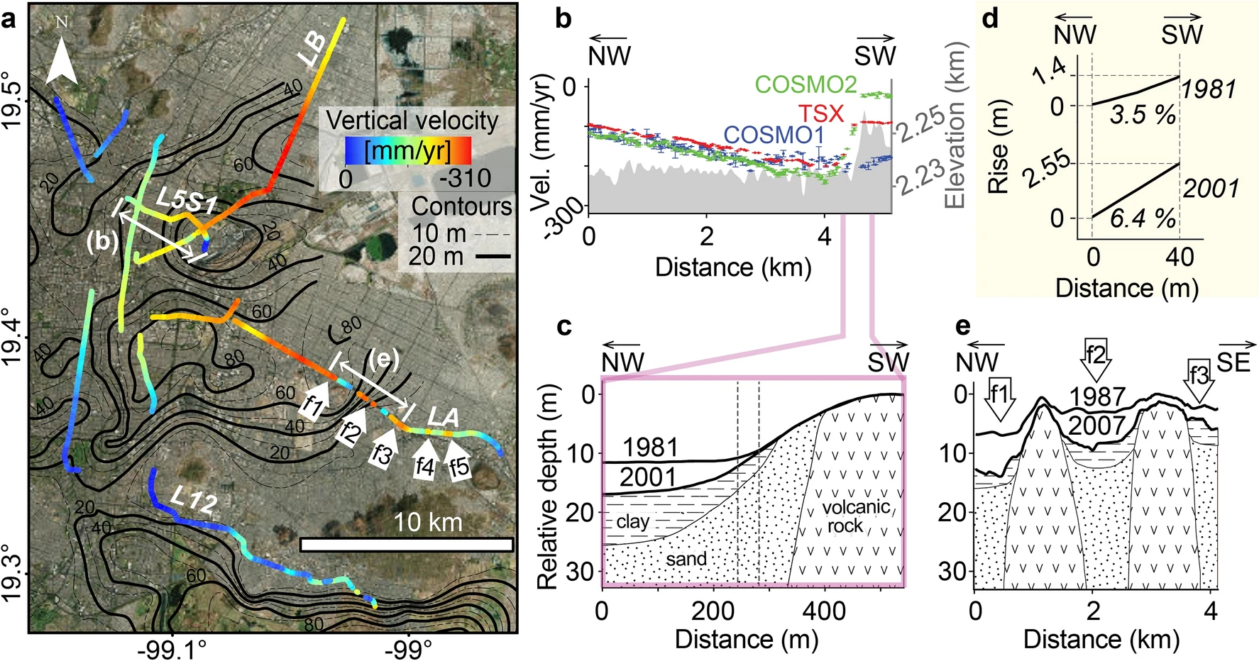
Subsidence along street-level and elevated lines of Mexico City Metro. Satellite imagery credits: INEGI and Maxar Technologies.
In 2021, an overpass located near the Olivos station collapsed onto the road as a train was traveling over it, resulting in more than 20 deaths. This occurred along a metro line that had been in operation less than 10 years. It was following this tragic accident that system authorities became aware subsidence-related structural damage existed. This discovery led to major repairs to two of the twelve metro lines. Still, the need for quantifying the magnitude and extent of the subsidence’s effects on the metro system’s widespread infrastructure remained. This study was designed to help determine those effects and provide data that could help prevent similar events.
Using a remote sensing approach, the study’s researchers were able to evaluate land subsidence throughout the metro’s different engineering designs and determine most of the damage was observed along street-level and elevated segments. The observed damage includes cracks, faults, railway deformation and topographic slope changes which can lead to recurrent flooding, reduced train speed, service interruptions and accidents like the collapse of 2021.
“Our analysis provides key information that can be incorporated in the root cause analysis of the Olivos accident as well as in the evaluation of other vulnerable line segments. It can provide insights into the future development of the Metro lines,” said lead author Darío Solano-Rojas, former FIU postdoctoral researcher and current geophysics professor at La Universidad Nacional Autónoma de México.
The research team recommends similar geohazard evaluations be conducted for other infrastructure in Mexico City and other highly subsiding areas throughout the world. The data could inform proactive measures to assess and mitigate the risks posed by widespread land subsidence.
The study was recently published in the journal Scientific Reports.